 John
Muir Wilderness John
Muir Wilderness
John
Muir Wilderness John
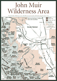
Muir Wilderness [Fig. 42, Fig. 43, Fig. 44] The John Muir Wilderness offers visitors a lot of room for hiking, backpacking, fishing, camping, horseback riding, and bird-watching. At 581,000 acres, it is about two-thirds the size of Yosemite National Park. And the Muir wilderness has no traffic-filled hub like Yosemite Valley, although there are parts of this Eastern Sierra area that are filled with people.
The wilderness stretches almost 100 miles along the Sierra crest in Central California, ranging from the upper foothills at 5,000 feet to the alpine areas above 14,000 feet. The majority of the wilderness is on the Eastern Sierra where the Inyo National Forest manages it. But there are substantial sections of the wilderness on the western slope, which the Sierra National Forest manages.
The John Muir Wilderness contains many streams, lakes, and glacially carved canyons. Dozens of glacial tarns include Duck Lake, Lake Virginia, Big Bear Lake, Desolation Lake, Merriam Lake, and Consultation Lake. Most high-elevation lakes are filled with snowmelt and teeming with rainbow trout (Oncorhynchus mykiss) and Eastern brook trout (Salvelinus fontinalis). The southernmost glacier in the United States is located in the Muir wilderness, and a major part of Mount Whitney is in the wilderness. At 14,497 feet, it is the tallest mountain in the contiguous United States.
Also within the wilderness is the Bighorn Sheep Zoological Area where the California bighorn (Ovis canadensis) is protected. This 200-pound mammal is nearing extinction. The sheep have died in great numbers after having brief contact with domestic sheep. The domestic sheep pass a common virus that is fatal to bighorn. But the bigger danger, by far, is the mountain lion (Felis concolor), a tenacious predator that has been specially protected in California since the early 1990s.
As the mountain lion populations have grown in the 1990s, the bighorn have been forced to feed at higher elevations, even in colder weather, to avoid contact with the big cat. The result has been a higher mortality rate for young sheep and many deaths by avalanche.
These mountain sheep have dwindled to a total of about 100 animals, one-third the number that existed about eight years ago. They have received emergency protection under the U.S. Endangered Species Act. Federal officials hope they can fend off the mountain lion long enough to bring back the populations in the Muir wilderness, which has most of the remaining bighorn in the Sierra.
 The
wilderness was named after John Muir, America's most famous and influential
naturalist and conservationist. Muir was known for solo journeys into the
Sierra Nevada, among Alaska's glaciers, and across the world. Muir, the
first president of the Sierra Club, traveled these parts as well.
The
wilderness was named after John Muir, America's most famous and influential
naturalist and conservationist. Muir was known for solo journeys into the
Sierra Nevada, among Alaska's glaciers, and across the world. Muir, the
first president of the Sierra Club, traveled these parts as well.
He might recognize the geologic features, the flora, and the fauna these days, but things have changed a lot since Muir hiked these mountains. Some trails have become so crowded that quota systems have been established to protect the wilderness and the solitude of hikers and backpackers. Overnight trips require an entry permit in this wilderness, but day trips do not require a permit.
Those who venture very far into the Muir wilderness will see the highest part of the Sierra. This is where uplift of the Sierra batholith has been the most dramatic over the past 5 million years. Whitney is not the only 14,000-foot peak. Mount Russell, north of Whitney, is 14,086 feet; Mount Muir to the south is 14,015 feet.
Geologists say these mountains continue to rise. The jagged peaks form a sawtooth against the horizon because of vertical joints that developed in the batholith many millions of years ago. Though the granite in the Muir wilderness looks pretty worn and old in some places, it is among the youngest rock in this part of the range—forming perhaps 80 million years ago, as opposed to some that formed more than 150 million years ago.
The glacial erosion is not difficult to see in many places in the wilderness area. For instance, at 14,200-foot North Palisade, there is an obvious knife-edged ridge or arete, as geologists call it. It is a sharp rock ridge with cirques on either side of it. The cirques look like deep canals flowing on either side of the ridge, a high spot in the granite that resisted the glacial flow.
To see these features, visitors have to hike or ride stock animals into the wilderness. No motorized or mechanized transportation, including bicycles, is allowed in the wilderness. Wheelchairs are permitted. The wilderness can be entered from the west through Sequoia-Kings Canyon National Parks and from several major trails on the eastern side.
[Fig. 42(1)] This is a hike for people determined to see the John Muir Wilderness. As with many hikes into the Muir wilderness, it is not easy, but it is worth the view of Duck Lake and Pika Lake from Duck Pass at 10, 800 feet. Don't bring the children on this hike, but make sure you have the camera and give yourself some time. There is a lot to see along the way.
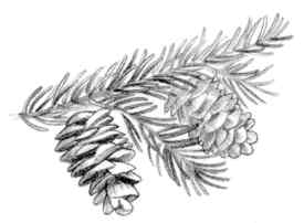
The high Sierra on this trail is striking. The lodgepole pine (Pinus murrayana) and the mountain hemlock (Tsuga mertensiana) are a graceful backdrop, particularly in the spring when snow lingers. Notice that the tips of saplings may not be completely straight after a long winter and a lot of snow. Watch for small groupings of silver pine (Pinus monticola), a beautiful pine tree that is not abundant but can survive above 9,000 feet in this part of the Sierra.
Up on the wind-blown pass above 10,000 feet, wildflowers cling to life in the rock crannies. Look for mountain sorrel (Oxyria digyna) and rock fringe (Epilobium obcordatum). Down by the lake, where people relax in the afternoon, the alpine buttercup (Ranunculus eschscholtzii) blooms a bright yellow flower in wet meadows nearby. They are most noticeable just days after the snowmelt.
[Fig. 44(1)] For those who want to see Big Pine Canyon, Big Pine Lakes, and part of the Palisades Glacier from a distance, this walk is for you. It can be done in one day, though it is a tough hike. The hike rewards visitors with wonderful views of the high Sierra.
Many of the glacial features studied so extensively in Yosemite National Park are present here. The "chatter" or scars and gouges left in the granite are visible in the canyon along the creek. About 6 miles into the hike among the Big Pine Lakes, visitors will see a small portion of the Palisade Glacier. The glacier's bergschrund, a geologist's term for a crack in the head wall of the glacier, is not visible from the trail, but the newly formed moraine—long hills of sand and gravel at the end of a glacier—can be partially seen.
There are other, smaller glaciers higher in the surrounding Sierra. Most are between 11,000 and 13,000 feet in places such as Mount Goddard, Mount Humphreys, and Glacier Divide. Nestled in cirques and north-facing mountainsides, they are puny compared to their Ice Age ancestors. They are not even mentioned in the same breath with today's large glaciers in Antarctica or on Mount Everest where they can have a head wall more than a mile high.
But the tarns left in the Eastern Sierra are impressive. Big Pine Lakes area consists of five lakes, plus Summit Lake and Black Lake. These bodies of water are featured in this hike. The lakes are various shades of blue and turquoise, depending on the season and the time of day. In warm weather, look for the mountain bluebird (Sialia currucoides) and the Clark's nutcracker (Nucrifraga columbiana). But when the weather starts turning in early September, these birds leave for lower elevations.
[Fig. 44(2)] People walk to Dorothy Lake to get away from crowds for some fishing or picnicking, or both. It will not take up much of the morning to hike in and find a nice spot to fish for rainbow trout or Eastern brook trout.
In the moist meadows along this hike, look for Suksdorf's monkeyflower (Mimulus suksdorfi) and glaucous larkspur (Delphinium glaucum). Also notice the meadow penstemon (Penstemon rydbergii).
Read and add comments about this page