 Golden
Trout Wilderness Golden
Trout Wilderness
Golden
Trout Wilderness Golden
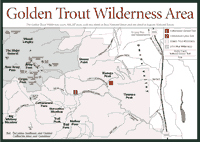
Trout Wilderness [Fig. 46] The 303,287-acre Golden Trout Wilderness, on the southeastern flank of the Sierra Nevada, attracts backpackers, hikers, fishing enthusiasts, and horseback riders. Almost two-thirds of the wilderness is in the Inyo, and the rest is in Sequoia National Forest on the western slope. The Golden Trout is considered an ideal choice for novice backpackers and stock users because its gentle hills and lower elevations are easily accessible in spring when the high country is still under snow. There are many trails on the eastern portion of the wilderness, which is on the Kern Plateau, a broad, high plateau above the Kern River Canyon. The plateau covers about 600,000 acres in the Southern and Eastern Sierra.
 The
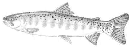
golden trout (Salmo aguabonita), California's state fish, is native
to the streams in this area, existing for perhaps thousands of years in
the drainages of the upper Kern River. It developed as a distinct species
from the rainbow trout, and it has been transplanted into many streams throughout
the Central Sierra. Two subspecies of golden trout are also found in the
wilderness. They are called Volcano Creek golden trout (Oncorhynchus
aguabonita) and Little Kern River golden trout (Salmo aguabonita
whitei), considered a threatened species. The golden trout fisheries
have been threatened by the introduction of the brown trout (Salmo trutta),
a European native fish. The brown trout prey on golden trout. Another problem
for the golden trout is interbreeding with the rainbow trout. Of the 117
miles of streams in the Little Kern River drainage, fewer than 10 miles
now contains pure populations of golden trout. A golden trout restoration
program has been ongoing for many years.
The
golden trout (Salmo aguabonita), California's state fish, is native
to the streams in this area, existing for perhaps thousands of years in
the drainages of the upper Kern River. It developed as a distinct species
from the rainbow trout, and it has been transplanted into many streams throughout
the Central Sierra. Two subspecies of golden trout are also found in the
wilderness. They are called Volcano Creek golden trout (Oncorhynchus
aguabonita) and Little Kern River golden trout (Salmo aguabonita
whitei), considered a threatened species. The golden trout fisheries
have been threatened by the introduction of the brown trout (Salmo trutta),
a European native fish. The brown trout prey on golden trout. Another problem
for the golden trout is interbreeding with the rainbow trout. Of the 117
miles of streams in the Little Kern River drainage, fewer than 10 miles
now contains pure populations of golden trout. A golden trout restoration
program has been ongoing for many years.
The Kern River Canyon, where the golden trout occurs, is considered an anomaly of sorts in the Sierra Nevada. All the major canyons of the Sierra are roughly parallel to each other and cut at right angles to the crest of the mountain range. The Kern, however, runs due south, winding up at a terminal lake in the southern San Joaquin Valley. It is different simply because faults in the Sierra developed in a north-south direction in this part of the range.
The elevations in the Golden Trout Wilderness run from about 5,000 feet at the Forks of the Kern River to 12,900-foot Cirque Peak at the edge of the John Muir Wilderness. The Golden Trout's lower elevations, below 6,500 feet, are dominated by the ponderosa pine (Pinus ponderosa) and Jeffrey pine (Pinus jeffreyi). Between 6,000 feet and 10,000 feet, there are three distinct forest communities. They include the white fir (Abies concolor) forest and sugar pine (Pinus lambertiana) forest, the red fir (Abies magnifica) forest, and the Sierra juniper (Juniperus occidentalis) forest. The foxtail pine (Pinus balfouriana) is a hardy tree found high in the Kern Plateau. Another high Sierra conifer found here is the limber pine (Pinus flexilis), which grows in isolated places and is rarely seen by hikers. To see this pine, you'll have to get off trails and perhaps scramble over boulders to find the dry, rocky, secluded places where it grows. Unless you have a compass, a map, and good path-finding skills, it is not a good idea to leave any trail in the Sierra.
The wildlife of the Golden Trout Wilderness include the marten (Martes americana), beaver (Castor canadensis), mountain lion (Felis concolor), mountain coyote (Canis latrans), black bear (Ursus americanus), wildcat (Lynx rufus), and mule deer (Odocoileus hemionus). About 6,000 acres of the Tule River deer herd range are within the wilderness. The Kern River deer herd and the Monache deer herd also are found here.
The peregrine falcon (Falco peregrinus anatum), the bald eagle (Haliaetus leucocephalus), and the California bighorn sheep (Ovis canadensis californiana) are endangered species found in the wilderness. The wolverine (Gulo luscus), the Kern Canyon slender salamander (Batrachoseps simatus), and the fisher (Martes pennanti) are considered rare species here. Cattle and sheep grazing took place in this area more than a century ago. Sheep were excluded from the Kern Plateau in 1893 because the meadows were becoming too degraded. Cattle grazing continued in major meadows, which were converted into "cow camps" where the ranchers set up their summertime headquarters. Although the cow camps have decreased in number since the 1950s, they continue today. The ranchers and the timber industry established many of the current trails.
Though mining is not a big activity in the Golden Trout, geologists know the area has tungsten, molybdenum, titanium, lead, and gold. Tungsten is mined at the Pine Tree Mine, the only active mine in the area. But thousands of years before grazing or mining, the Golden Trout Wilderness and the rest of the Kern Plateau served as a summer destination for Native Americans who hunted and gathered food here. The tribes are still around this area today. They are the Paiute and the Shoshone on the eastern side of the plateau.
Travel in the Golden Trout Wilderness requires a wilderness permit for overnight camping. Hikers and equestrians both use the area. Campfires are allowed with a proper campfire permit where no resource damage will be done. Permits can be obtained from the ranger station at Lone Pine. Use of backpacker stoves instead of campfires is encouraged.
[Fig. 46(1)] The trip down Cottonwood Creek Canyon is laced with history, an Eastern Sierra stream ecosystem, and views in the Golden Trout Wilderness. Start the trip early because it is all downhill on the way, but hikers have to turn around and go back uphill for the return trip.
The human history here includes the Stevens Sawmill, which supplied timber to the mining town of Cerro Gordo in the Inyo Mountains. The mill was abandoned in the late 1800s, and fire destroyed it. An old log cabin, once used by loggers, remains farther along the trail. A little more than 1 mile into this hike, you must cross Cottonwood Creek at about 7,800 feet. Most of the time, it is not a big concern, but it is dangerous in times of heavy snowmelt. In late May and June, it is wise to avoid this crossing and this trail. Like most Sierra streams, the flow can be deceiving—low in the morning and quite high in the afternoon as the snowmelt picks up. The vegetation in the area is typical at this elevation. Red fir (Abies magnifica) and lodgepole pine (Pinus murrayana) dominate. Also look for the blue elderberry (Sambucus caerulea) and red elderberry (Sambucus racemosa), especially in the moist, open areas along the trail.
[Fig. 46(2)] The views and the fishing are the attractions on this trail. Most of it is in the Golden Trout Wilderness, but the Cottonwood Lakes are actually in the John Muir Wilderness. Nevertheless, if golden trout fishing is your passion, this is a prime fishing area for you. From this trail, hikers get the full view of pinion pine (Pinus monophylla) and Sierra juniper (Juniperus occidentalis) in the surrounding meadows. In fall, the leaves of the quaking aspen (Populus tremuloides) turn golden yellow and quiver in any breeze. Beavers (Castor canadensis) rely on the bark of the quaking aspen for food.
Closer to the streams, hikers will see the water birch (Betula occidentalis), a tree that is found only sporadically through the Sierra. Understory vegetation in many areas includes Idaho fescue (Festuca idahoensis) and basin wild rye (Elymus cinereus). At the end of the trail, hikers come to the striking Cottonwood Lakes. Among these glacial lakes are Long Lake, High Lake, Muir Lake, and Hidden Lake.
Read and add comments about this page